In Photos and Words

Posts tagged ‘Carrickmacross’

Inniskeen

Peaceful Island

Inniskeen

Inniskeen

Inniskeen, officially Inishkeen (Irish: Inis Caoin, meaning “peaceful island”), is a small village and parish in County Monaghan, Ireland, close to the County Louth and County Armagh borders. It is located about 17 km from Dundalk and 12 km from Carrickmacross and 5 km from Crossmaglen (here are directions how to get there).

This territory had been inhabited from the late Neolithic/Early Bronze Age. Rock art carvings (Petroglyphs) have been discovered in adjoining townlands (including Drumirril) dating to 3000 BC. Cup and ring markls with concentric circles are the main inscriptions.

Old Church

Old Church

A monastery was founded here in the 6th century by Saint Daigh MacCarell which was burned in 789, plundered by the Vikings in 948, and burned a second time in 1166. The bottom third of the round tower remains. In this drumlin country many of the hill tops have hill forts and associated souterrains which date from the late Iron Age or early Christian era. The country was part of McMahon Clann territory who displaced Carrolls in the 9th century as the dominant force in the area.

Patrick Kavanagh

Patrick Kavanagh

The arrival of the Normans saw the construction of a Motte-and-bailey in the 13th century, The motte is still standing. The arrival of the Augustinian order of monks saw the construction of a new monastery of that order as a branch of the Abbey at Louth. One section of its wall remains adjoining the graveyard in the field adjoinhing the Motte.

The Patrick Kavanagh Centre is set up to commemorate the poet Patrick Kavanagh.The Centre houses exhibitions outlining Kavanagh’s lifestory and local history. It is located in the former RC St. Mary’s church in whose adjoining graveyard Kavanagh and his wife are buried.

This slideshow requires JavaScript.

Carrickmacross Walk

Two lakes walk

Lisanisk Lake

Lisanisk Lake

The old garrison town of Carrickmacross has two heritage routes, one 2.7km and the other 2.5km. Between them, the two routes – taking 35-40 minutes each to walk – are the perfect opportunity to get under the skin of this Co. Monaghan crossroads.

But there is another option – kind of combination of these two routes – walk which will take you pass two lakes – Lisanisk Lake and Lough Naglack – and will take about 1 hour to walk. Here is the map of the route and here directions how to get there.

Tunnel

Tunnel

Our walk starts from the parking lot of Lisanisk Lakeside Park. It is a nice park beside a small lake which seems to be very popular among fishermen.

Other great part of this walk is a route beside Lough Naglack. There is a grove of old trees which grow beside the lake and will give you a feeling like you are in the deep forest.

Last part of the route takes you through town and back to parking lot. Enjoy 🙂

This slideshow requires JavaScript.

Ballybay

Town between two lakes

Ballybay

Ballybay

Ballybay (Irish: Béal Átha Beithe, meaning “mouth of the ford of the birch”) is a town in County Monaghan in Ireland, centered on the crossroads of the R183 and R162 regional roads (click here for directions).

The town is the meeting point for roads going to Monaghan, Castleblayney, Carrickmacross and Clones.  The town is built beside a large lake, Lough Major (In Irish “Lough Mór”) and the smaller Lough Minor. The Dromore River also runs through the south of the town, past Pearse Brothers Football Grounds, and past the Riverdale Hotel.

Lough Major

Lough Major

The town grew up in the 18th century, gaining its prosperity from the linen industry founded by the Jackson family. The Town council (Ballybay Development Committee) was established around 1870.

Today the town welcomes a large number of tourists a large proportion of whom are bird watchers who frequent the town to make use of the newly renovated lake district built around the local Lough Minor. The town is also a popular destination for fishermen who travel to the town to take part in various fishing competitions.

This slideshow requires JavaScript.

Carrickmacross Photos

Rock of the Wooded Plain

Irish: Carraig Mhachaire Rois, meaning “rock of the wooded plain”) is a busy market town, located centrally between Dundalk, Monaghan town, Cavan and Ardee. Read  more about Carrickmacross and get directions by clicking HERE

Dun an Rí Forest Park

Dun an Rí Forest Park is located 1.5km north of Kingscourt on the R179 to Carrickmacross.

Park

Park

The Forest Park embraces part of the Cabra Estate, which was formerly owned by the Pratt family. It is situated in the parish of Enniskeen, which includes a portion of the Barony of Clonee, Co. Cavan and a smaller part of the Barony of Kells, Co. Meath. The O’Reilly family ruled the area until the end of the 16th century when they were succeed by the Flemings who built Felming’s Castle at Cabra in 1605. In 1666, Col. Thomas Cooch, a forebear of the Pratt family, came into possession of the estate. The ‘Romantic Glen’ of the Cabra River, stretching the full length of the park is an area steeped in history and legend. It is said that Cuchulain camped here at night while conducting his single-handed defense of Ulster against the armies of Queen Maeve by day. Eilis Boland who wrote the famous ballad “Doonaree” wrote about “the wishing well, beyond the chestnut tree in a shady nook, by a winding brook…” The chestnut tree still stands and is a feature of the parkland.

Chestnut Tree

Chestnut Tree

The park is located in an area noted for the diversity of its geological formations. The forest itself lies in a tranquil glen. Lady’s lake is an artificial lake, which was fed from water passing through the old flax mill at Cabra. The Cabra River runs through the park.

Lady's Lake

Lady’s Lake

Walking Paths

Walking Paths

There are a number of different walking paths in Dun an Rí. There are four walks of approximately 1.5-2km in length all with points of interest.

The forest of Dun an Rí is 229 hectares of which 146 hectares comprises of commercial forest. Norway spruce and oak are two important species in these commercial stands. The oak trees are managed to produce a valuable veneer crop.

There are various features identified by sign posts in the course of the several planned walks These include the wishing well, (a Holy Well called Tobar na Splinne), Cromwell’s Bridge, Cabra Cottage – originally the residence of the Pratt family before they moved to Cabra Castle – the flax mill, the Lady’s Lake and an old ice house. The ruins of Fleming’s Castle can still be seen as well as Sarah’s Well. Sarah’s Bridge, built in 1801, is the starting point of many of the walks in the park. Car parking is also available. (source: http://www.coillte.ie)

Frog

Frog

Entrance fee per car is €4. But be aware that you can pay only in coins (€1 or €2) and there is nothing nearby to get a change.

Dun an Rí Photo Gallery

Dun an Rí Directions

Carrickmacross

Carrickmacross

Carrickmacross

Carrickmacross

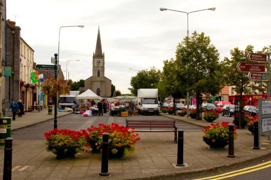
Carrickmacross (Irish: Carraig Mhachaire Rois, meaning “rock of the wooded plain”) is a busy market town, located centrally between Dundalk, Monaghan town, Cavan and Ardee. The town and environs had a population of 4,925 according to the 2011 census, making it the second largest town in the Monaghan County.

Carrickmacross is always a busy town, but especially on Thursdays when there is a Market Day.

Market Day

Busy Market Day

There are some pretty awesome buildings in Carrick but in my opinion one of the best is St.Louis Convent.

St Louis Convent

St Louis Convent

If you like to walk as I do, then there is a great walking path which is about 5 km long and takes you by 2 lakes and some forest. Nice walk.

Walking Path

Walking Path

Carrickmacross is a well decorated and “flowery” town regardless of season.

Flowers

Flowery Carrickmacross

All non Irish speaking people, have you ever wondered, what the word “slan” means? I can tell you: it means “farewell”.

Slan

Farewell

See you in Carrick! You will find directions how to get to Carrickmacross from HERE.
To see more photos click here: Carrickmacross Photo Gallery